Here’s an informative article by Amanda Briney for Thought Co. on the main islands of Hawaiʻi. A great way to explore the Big Island in luxury is a tour on Kailani Tours Hawaiʻi
Hawaiʻi is the youngest of the 50 states of the U.S. and the only one that is entirely an archipelago, or chain of islands. It’s located in the central Pacific Ocean, southwest of the continental U.S., southeast of Japan, and northeast of Australia. It is made up of over 100 islands, and of the eight main islands that make up the Aloha State, only seven are inhabited.
Hawaiʻi (the Big Island)
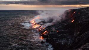
The island of Hawaiʻi, also known as the Big Island, is the largest of Hawaiʻi’s main islands with a total area of 4,028 square miles (10,432 square kilometers). It is also the largest island in the United States, and like the other islands of Hawaiʻi, was formed by a hotspot in the Earth’s crust. It is the most recently formed of Hawaiʻi’s islands, and as such it is the only one that is still volcanically active. The Big Island is home to three active volcanoes, including Kilauea, one of the most active in the world.
The highest point on the Big Island is the dormant volcano Mauna Kea at 13,796 feet (4,205 meters). The Big Island has a total population of 148,677 (as of 2000) and its largest cities are Hilo and Kailua-Kona (normally called Kona).
Maui
Maui is the second largest of Hawaiʻi’s main islands, with a total area of 727 square miles (1,883.5 square kilometers). Maui’s nickname is the Valley Isle, and its topography reflects its name. There are lowlands along its coasts with several mountain ranges that are separated by valleys. Maui is known for its beaches and natural environment. Maui’s economy is based mainly on agriculture and tourism, and its main agricultural products are coffee, macadamia nuts, flowers, sugar, papaya, and pineapple.
The highest point on Maui is Haleakala at 10,023 feet (3,055 meters). It has a population of 117,644 people (as of 2000), and its largest town is Wailuku. Other towns include Kihei, Lahaina, Paia, Kula, and Hana.
Oahu
Oahu is the third largest island of Hawaiʻi, with a total area of 597 square miles (1,545 square kilometers). It is called the Gathering Place because it is the largest of the islands by population, and it is the center of Hawaiʻi’s government and economy.
Oahu’s topography consists of two main mountain ranges that are separated by a valley as well as coastal plains that ring the island. Oahu’s beaches and shops make it one of Hawaiʻi’s most visited islands. Some of Oahu’s top attractions are Pearl Harbor, the North Shore, and Waikiki.
Oahu’s population 953,307 is people (2010 estimate). The largest city on Oahu is Honolulu, the capital of the state of Hawaiʻi. Oahu is also the home of the largest U.S. Navy fleet in the Pacific at Pearl Harbor.
Kauai
Kauai is the fourth largest of Hawaiʻi’s main islands and it has a total area of 562 square miles (1,430 square kilometer). Kauai is known as the Garden Isle for its undeveloped land and forests. It is also home to the Waimea Canyon and Na Pali Coast state parks. Tourism is the main industry on Kauai, and it is located 105 miles (170 km) northwest of Oahu.
Kauai’s population is 65,689 (as of 2008). It is the oldest of the main islands, as it is located furthest away from the hotspot that formed the archipelago. As such, its mountains are more highly eroded; its highest point is Kawaikini, at 5,243 feet (1,598 meters). Kauai’s mountain ranges are rugged, however, and the island is known for its steep cliffs and rugged coastline.
Molokai
Molokai has a total area of 260 square miles (637 square kilometers) and it is located 25 miles (40 kilometers) east of Oahu across the Kaiwi Channel and north of the island of Lanai.
Molokai’s topography consists of two distinct volcanic ranges, known as East Molokai and West Molokai. These mountains, however, are extinct volcanoes that have since collapsed. Their remains give Molokai some of the highest cliffs in the world. In addition, Molokai is known for its coral reefs, and its south shore has the world’s longest fringing reef.
The highest point on the island, Kamakou at 4,961 feet (1,512 meters) is a part of East Molokai. Most of Molokai is part of Maui County, and it has a population of 7,404 people (as of 2000).
Lanai
Lanai is the sixth largest of the main Hawaiʻian Islands, with a total area of 140 square miles (364 square kilometers). Lanai is known as the Pineapple Island because, in the past, the island was covered by a pineapple plantation. Today, Lanai is mainly undeveloped, and many of its roads are unpaved. There are two resort hotels and two famous golf courses on the island and as a result, tourism is a large part of its economy. The only town on the island is Lanai City, and the island has a population of only 3,193 (2000 estimate).
Niihau
The smallest of the inhabited islands with an area of just 69.5 square miles (180 square kilometers), Niihau is one of the lesser known. Niihau is an arid island because it is in the rainshadow of Kauai, but there are several intermittent lakes on the island that provide wetland habitat to a number of endangered plants and animals. As a result, Niihau is home to seabird sanctuaries.
Niihau is also known for its tall, rugged cliffs and the majority of its economy is based on a Navy installation which is located on the cliffs. Aside from the military installations, Niihau is undeveloped, and tourism is non-existent on the island. Niihau has a total population of only 130 (as of 2009), most all of whom are Native Hawaiʻians.
Kahoolawe is the smallest of Hawaiʻi’s main islands, with an area of 44 square miles (115 square kilometers). Like Niihau, Kahoolawe is arid. It is located in the rainshadow of Haleakala on Maui. Because of its dry landscape, there have been few human settlements on Kahoolawe, and it was used historically by U.S. military as a training ground and bombing range. In 1993, the State of Hawaiʻi established the Kahoolawe Island Reserve.
As a reserve, the island can only be used for Native Hawaiʻian cultural purposes, and any commercial development is prohibited, today. Uninhabited, it is located 7 miles (11.2 kilometers) southwest of Maui and Lanai, and its highest point is Pu’u Moaulanui at 1,483 feet (452 meters).


